Sentiero dell'Inglese, a picturesque hiking trail located in Aspromonte in Calabria, offers exceptional opportunities to discover Greek culture and nature. The section connecting Bova and Amendolea delights with its diversity of landscapes and historical attractions. Thanks to easy access and a moderate difficulty level, it is an excellent choice for tourists with basic physical fitness. Plan your trip to fully enjoy the charm of this region.
Table of Contents
Discovering the Greek Legacy on the Sentiero dell'Inglese
Passing through the picturesque terrain of Aspromonte, Sentiero dell'Inglese not only offers spectacular views and contact with nature but also transports tourists back in time, enabling them to discover the rich Greek heritage present in Calabria. This trail, also known as the Edward Lear Path, connects the cultural hearts of the region – Bova and Amendolea – which are steeped in traditions and history dating back to the times of Magna Graecia.
Bovesìa, also known as the Area Grecanica, is a Greek-speaking area within the metropolitan area of Reggio Calabria, encompassing towns such as Bova, Bova Marina, Condofuri, Gallicianò, Roghudi and Staiti. Bova itself is a member of the I Borghi più belli d'Italia association, and the local language is known as greco di Calabria or grecanico. Today its use is severely endangered and largely limited to older generations and cultural initiatives.
The ideological foundation of the trail lies in the notes left by Edward Lear, a British artist who traversed these lands in 1847. The result of that journey was the book Journals of a Landscape Painter in Southern Calabria, published in 1852. Lear was primarily a landscape draughtsman and travel writer, and the trail's name refers to his accounts and sketches from the area around Bova, Roghudi and the Amendolea valley.
Greek Roots of Magna Graecia
The Calabrian region harbours a history linked to Greek colonisation, which began as early as the 8th century BC. This area, known as Magna Graecia, transformed southern Italy into an important zone of contact between the Greek world and the Italian Peninsula. In the case of Bovesìa, however, it is worth remembering that the presence of Greek language and rites is also linked to the later Byzantine period, from the 6th to the 11th century AD.
The Grecanico heritage of Bova and its surroundings is therefore the result of overlapping ancient, Byzantine and medieval influences, rather than a simple continuation of a single era. It is precisely this multi-layered character that best explains the exceptional nature of the region and distinguishes it from simple associations with Magna Graecia alone.
Culture and Architecture
Walking along the Sentiero dell'Inglese, one can come across many traces of local culture rooted in the centuries-long history of the region. The characteristic agricultural terraces and buildings visible in Bova and Amendolea are primarily the result of traditional farming and long adaptation to the harsh, mountainous landscape. Modern-day Bova serves as one of the most important centres of the Bovesìa area, where the memory of Byzantine and Grecanico tradition remains alive.
Mythology and Art
On this trail, the landscapes and cultural memory of the place matter more than spectacular legends. They form the backdrop for the story of Bovesìa as a borderland region, where different languages, rites and ways of life overlapped for centuries. For local communities, Edward Lear became a symbol of European interest in this distinctiveness and one of the first careful observers of the local world.
Secrets of Aspromonte – Dynamic Nature and Terrain
Aspromonte, a mountain massif located in Calabria, is a remarkable example of the geographical and biological complexity of this Italian region. As the south-western extremity of the Apennines, Aspromonte offers spectacular views, attracting tourists from around the world. The Sentiero dell'Inglese trail enables the discovery of these charms during a hike among vegetation-covered peaks and picturesque valleys, where the boundary between mountains and sea is remarkably thin.
Terrain Formation
The Aspromonte region is characterised by a varied geological landscape, consisting mainly of crystalline metamorphic rocks such as gneisses and granites. The dominant landscape feature is the fiumare – wide, stony riverbeds that remain dry for most of the year. Fiumara Amendolea is the largest of these watercourses, constituting the structural axis of the entire regional topography and requiring hikers to be familiar with local hydrological conditions.
| Environmental Parameter | Characteristics of the Bovesìa Region |
|---|---|
| Main forest formations | Mediterranean maquis, holm oaks, pine forests |
| Terrain formations | Mountain ridges, fiumare, rock formations (Pentedattilo) |
| Highest point of the described section | Bova – approx. 820 m a.s.l. |
| Characteristic crop | Bergamot – a symbol of the Reggio Calabria metropolitan area, grown mainly along the coast |
Natural Wealth
Aspromonte is a unique ecosystem protected within Aspromonte National Park, rich in flora and fauna diversity. The Edward Lear Trail enables direct contact with a mosaic of Mediterranean vegetation, ancient olive groves, and drier, stony slopes descending toward the valleys. The scent of bergamot is characteristic primarily of the lower, coastal zones of the province of Reggio Calabria and does not accompany the hike along the entire mountain section.
Watch on YouTube
Discovering the Trail from Bova to Amendolea – Attractions and Activities
The section connecting Bova with Amendolea is widely regarded as the heart of the Sentiero dell'Inglese. It can be completed in both directions, with the march from Amendolea to Bova being an intense ascent with significant elevation gain. The route from Bova to Amendolea leads mainly downhill, making it easier to complete, but still requiring sturdy footwear and caution on stony ground.
| Technical Parameter | Direction: Bova – Amendolea |
|---|---|
| Distance | approx. 7.9 – 8.0 km |
| Negative elevation | approx. -834 m |
| Maximum altitude | 820 m a.s.l. (Bova) |
| Walking time | approx. 3.5–5 hours |
In practice, the Bova Superiore – Amendolea Vecchia section is about 8 km and usually takes 3.5 to 5 hours. Walking time depends on trail conditions, temperature, and whether you have pre-arranged return transport. If you return along the same route, the final stretch means a long, tiring ascent from the valley back up to Bova.
The Village of Bova
Bova, known as Chòra, is the ideal place to begin the hike. It sits at approximately 820 m above sea level and is historically regarded as the most important centre of the Area Grecanica. A walk through the village reveals its medieval borgo layout, castle ruins on the hilltop, and the co-cathedral associated with the cult of the Madonna dell'Isodia.
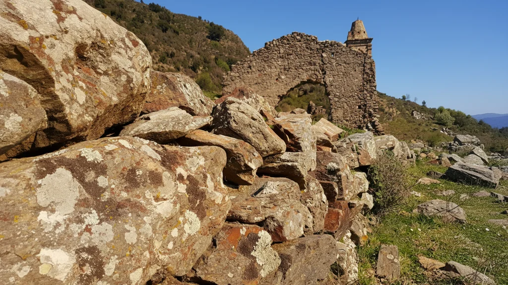
Amendolea Vecchia – Historic Ruins
Near Amendolea lie the ruins of Amendolea Vecchia, one of the mountain settlements of the Area Grecanica affected by floods, landslides and progressive depopulation during the 20th century. Following catastrophic events and difficult living conditions, residents were gradually relocated to lower-lying towns and coastal areas. The area is dominated by a medieval castle later associated with the Ruffo family, which for centuries controlled movement in the valley.
Linguistic Heritage and Gastronomy
This area is one of the few places where Calabrian Greek, known as greco di Calabria or grecanico, is still used. Encounters with local elders who still remember this language are more the exception than the rule today, but they vividly illustrate the cultural distinctiveness of Bovesìa. Among the most local flavours are lestopitta, goat and sheep cheeses, olive oil, mountain oregano, and simple pastoral baked goods and dishes. Bergamot remains an important symbol of the Reggio Calabria metropolitan area, though its main cultivation lies on the coast, not in the mountain village of Bova itself.
Aspromonte National Park – The Heart of Calabrian Tourism
Aspromonte National Park attracts attention thanks to its numerous natural attractions and opportunities for active recreation. Trails of varying difficulty levels enjoy great popularity, and the Sentiero dell'Inglese is one of those routes that most strongly connect landscape with local history.
For history enthusiasts, the ruins and former settlements scattered across the Bovesìa area are a true treat. Aspromonte also offers panoramic mountain landscapes whose scenery conceals traces of the region's multi-layered heritage. In towns such as Bova, the albergo diffuso model is being implemented – a dispersed hotel concept that allows the revitalisation of old houses and support of the local economy without destroying the historic urban fabric.
The best conditions for completing the trail usually fall in spring and autumn. In summer, heat and lack of shade on some sections are a problem, while in winter and after heavy rain, the difficulty increases due to slippery ground and the risk of flash floods in the fiumare. For a half-day hike, you should carry a minimum of 1.5–2 litres of water per person, trekking boots with good grip, and an offline map or GPS.
Frequently Asked Questions
How long is the Sentiero dell'Inglese and how long does it take to complete?
The most commonly described section from Bova to Amendolea is about 8 km and usually takes 3.5–5 hours. For the entire Sentiero dell'Inglese there is not always a single official distance, so it is best to treat it as a network or series of sections within the Area Grecanica.
Who was Edward Lear and why does the trail bear his name?
Edward Lear was a nineteenth-century English artist and traveller who traversed Calabria in 1847. The trail's name refers to his accounts and sketches from the area around Bova, Roghudi and the Amendolea valley.
How do you get to the start of the Sentiero dell'Inglese?
The nearest railway station for travel from Reggio Calabria is Bova Marina on the Ionian line. Bova Superiore lies high in the mountains above the coast, and bus connections between the marina and old Bova are limited and irregular, so a taxi or private car is often needed. Before setting off, it is also worth arranging return transport from the Amendolea or Condofuri area, as public transport from the valley can be very limited.
Is the trail safe for solo hikers?
The trail is safe provided you exercise caution when crossing fiumare after rain and carry GPS maps. It is also worth being aware of shepherd dogs guarding flocks in the higher parts of Aspromonte.
What is the Grecanico dialect encountered on the trail?
In this region it is more accurate to speak of Calabrian Greek, known as greco di Calabria or grecanico. It is a local variety of Greek strongly associated with the Area Grecanica, today preserved mainly among older generations and through cultural initiatives.