Calabria is a narrow, mountainous peninsula about 250 km long – the toe of the Italian boot, with the Tyrrhenian Sea to the west and the Ionian to the east. On a map everything looks close, yet driving from the northern edge of the region to Reggio Calabria takes three and a half hours on the motorway, and Tropea to Gerace – 50 km as the crow flies – takes more than an hour and a half. Below you will find a map of the main towns, the provinces and coasts, and tables of real road distances.
Contents
Map of Calabria
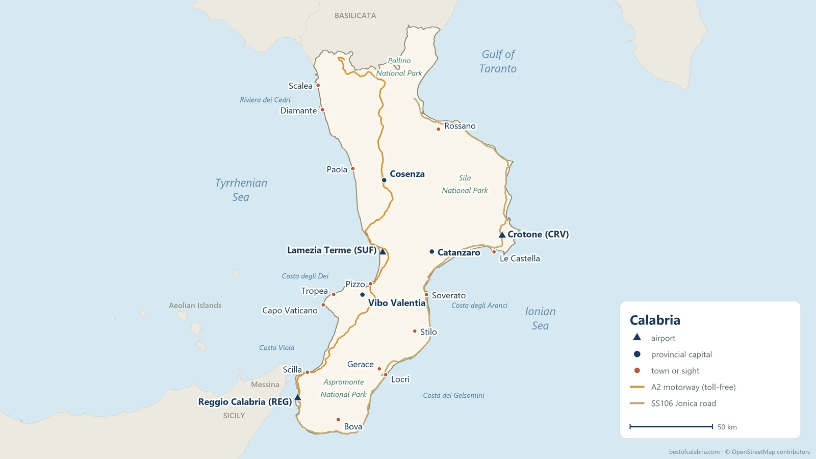
How to read the map:
- triangles mark the three airports: Lamezia Terme (SUF), Reggio Calabria (REG) and Crotone (CRV),
- navy dots are provincial capitals, red dots the towns and sights we write about on this site,
- the orange line is the toll-free A2 motorway, the backbone of the region: in the north it runs inland through Cosenza, and from Lamezia southwards closer to the Tyrrhenian coast,
- the light brown line is the SS106 Jonica, which runs the full length of the Ionian coast.
For a description of each place, see Things to do in Calabria: 25 places worth the trip.
Where Calabria is
Calabria occupies the southern tip of the Italian peninsula. To the north it borders a single region, Basilicata, and it is separated from Sicily by the Strait of Messina, just over 3 km wide at its narrowest point.
| Area | 15,222 km² (5,877 sq mi) – slightly larger than Northern Ireland |
|---|---|
| Population | about 1.82 million (ISTAT, mid-2026) |
| Regional capital | Catanzaro; the regional council sits in Reggio Calabria |
| Largest city | Reggio Calabria |
| Coastline | almost 790 km (490 miles) |
| Highest peak | Serra Dolcedorme, 2,267 m (Pollino massif) |
| Narrowest point | the Isthmus of Catanzaro – about 30 km between the two seas |
The shape of the region has practical consequences. The sea is never far away, but getting from one coast to the other means crossing mountains. The one exception is the Isthmus of Catanzaro: from Lamezia Terme airport on the Tyrrhenian side to Catanzaro Lido on the Ionian takes about half an hour on the fast SS280.
The five provinces
| Province | Location | What you will find there |
|---|---|---|
| Cosenza | the north, coast to coast – the largest | Cosenza, Pollino, Sila, Scalea, Diamante, Corigliano-Rossano |
| Crotone | the east, on the Ionian Sea | Crotone, Capo Colonna, Le Castella |
| Catanzaro | the middle, the isthmus between the seas | Catanzaro, Soverato, Lamezia Terme airport |
| Vibo Valentia | the west, on the Tyrrhenian Sea – the smallest | Tropea, Pizzo, Capo Vaticano |
| Reggio Calabria (metropolitan city) | the south, both coasts and the Strait of Messina | Reggio Calabria, Scilla, Gerace, Locri, Stilo, Bova, Aspromonte |
You will see the province codes on number plates and in addresses: CS, KR, CZ, VV, RC.
The coasts and their names
Stretches of the Calabrian coast have their own tourist names. They are worth knowing, because they turn up in accommodation listings and on road signs.
The Tyrrhenian Sea (west) – a rockier shore, with cliffs and coves:
- Riviera dei Cedri – the north, from the Basilicata border to around Paola: Praia a Mare, Scalea, Diamante. The name comes from the citron (cedro), a citrus fruit grown here for centuries.
- Costa degli Dei (Coast of the Gods) – from Pizzo through Tropea to Capo Vaticano and Nicotera. The best-known stretch, covered in our guide to the beaches of the Costa degli Dei.
- Costa Viola – from Palmi through Bagnara and Scilla to Villa San Giovanni, at the mouth of the Strait of Messina.
The Ionian Sea (east and south) – long, wide beaches, less development and fewer tourists:
- Costa dei Gelsomini (Jasmine Coast) – around Locri, Siderno and Roccella Jonica; Gerace sits on a hill about 10 km inland from Locri.
- Costa degli Aranci (Orange Coast) – the Gulf of Squillace, with Soverato and Catanzaro Lido.
- Costa dei Saraceni – around Crotone, with the Capo Rizzuto marine reserve and the castle of Le Castella.
- Costa degli Achei – the Sibari plain and Rossano in the north-east.
For help choosing, see our round-up of the beaches of Calabria.
Mountains and national parks
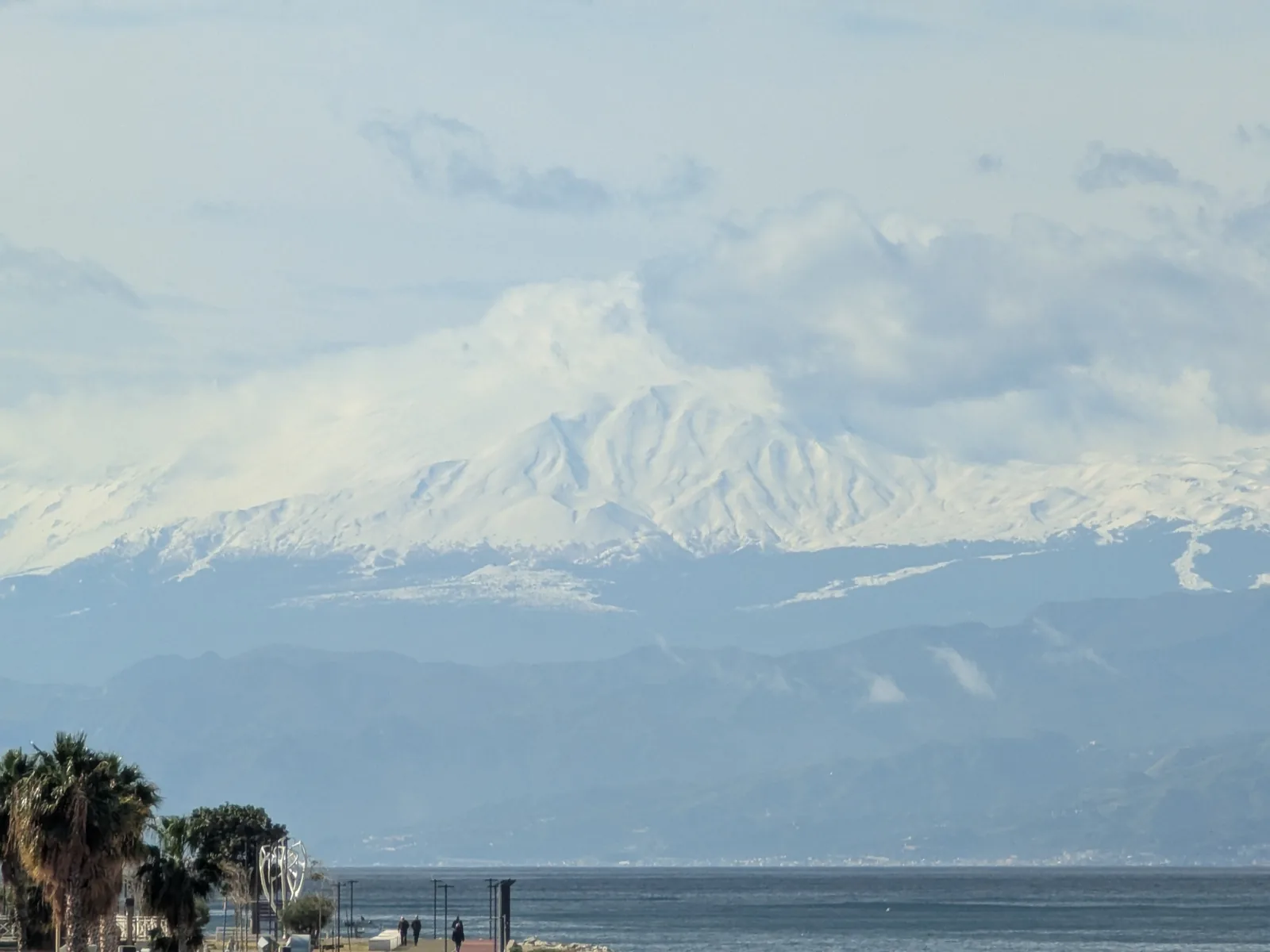
The middle of the region is filled with mountains – plains make up only about a tenth of Calabria. Four massifs run from north to south:
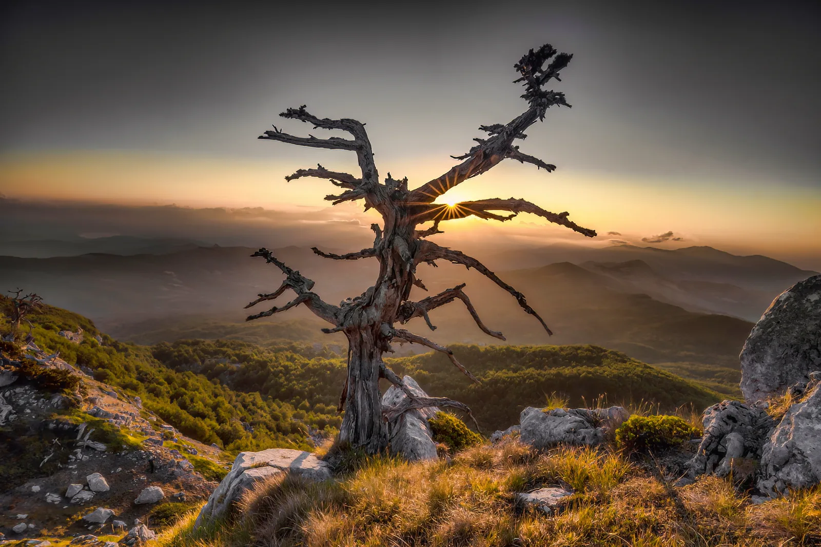
- Pollino – on the border with Basilicata, with the region’s highest peaks (over 2,200 m) and the Bosnian pine, pino loricato. The Pollino National Park is the largest national park in Italy.
- Sila – a vast forested plateau east of Cosenza, with the lakes Arvo, Cecita and Ampollino. Ski lifts operate here in winter.
- Serre – a lower, densely wooded range between the Isthmus of Catanzaro and the Aspromonte, with the charterhouse of Serra San Bruno and the Marmarico waterfalls.
- Aspromonte – the southern tip of the peninsula, with the summit of Montalto (1,956 m) and the Greek-speaking villages around Bova.
Airports and distances from them
Calabria has three passenger airports. Lamezia Terme (SUF) handles the most routes – it sits in the middle of the region, right on the A2 motorway. Reggio Calabria (REG) is the best starting point for the south, while Crotone (CRV) has only a handful of routes, mostly domestic. We describe the current flight network in our guide to getting to Calabria.
Road distances and driving times without stops (OpenStreetMap/OSRM, October 2026). In August, add 20–30 minutes on the coast roads.
| Destination | from Lamezia Terme (SUF) | from Reggio Calabria (REG) |
|---|---|---|
| Pizzo | 31 km, about 30 min | 110 km, about 1 h 25 min |
| Tropea | 55 km, about 1 h | 110 km, about 1 h 40 min |
| Catanzaro | 37 km, about 30 min | 164 km, about 2 h |
| Soverato | 59 km, about 50 min | 148 km, about 2 h |
| Cosenza | 66 km, about 1 h | 192 km, about 2 h 20 min |
| Camigliatello Silano (Sila) | 98 km, about 1 h 30 min | 225 km, about 2 h 55 min |
| Scilla | 106 km, about 1 h 15 min | 30 km, about 30 min |
| Reggio Calabria (centre) | 126 km, about 1 h 30 min | 9 km, about 15 min |
| Gerace | 120 km, about 1 h 40 min | 97 km, about 1 h 35 min |
| Stilo | 100 km, about 1 h 45 min | 145 km, about 2 h 10 min |
| Bova | 178 km, about 2 h 20 min | 48 km, about 1 h |
| Diamante | 105 km, about 1 h 55 min | 231 km, about 3 h 20 min |
| Scalea | 121 km, about 2 h 15 min | 247 km, about 3 h 40 min |
| Crotone | 103 km, about 1 h 40 min | 231 km, about 3 h 5 min |
From Crotone airport it is about 15 km to the city and to Le Castella, just under 60 km to Catanzaro (an hour’s drive) and just under 90 km to Camigliatello Silano on the Sila plateau (about 1 h 25 min).
Distances between towns
| Route | Distance | Driving time | Via |
|---|---|---|---|
| Tropea – Scilla | 83 km | about 1 h 15 min | local roads, A2 |
| Tropea – Reggio Calabria | 103 km | about 1 h 30 min | local roads, A2 |
| Tropea – Gerace | 86 km | about 1 h 40 min | local roads to Rosarno, then across the mountains on the SS682 |
| Tropea – Cosenza | 117 km | about 1 h 40 min | former SS522, A2 |
| Scalea – Tropea | 172 km | about 3 h | SS18, A2, former SS522 |
| Reggio Calabria – Locri | 110 km | about 1 h 30 min | SS106 |
| Reggio Calabria – Catanzaro | 157 km | about 1 h 50 min | A2, SS280 |
| Reggio Calabria – Cosenza | 185 km | about 2 h 10 min | A2 |
| Reggio Calabria – Crotone | 224 km | about 3 h | A2, SS280, SS106 |
| Catanzaro – Cosenza | 97 km | about 1 h 15 min | SS280, A2 |
| Catanzaro – Crotone | 71 km | about 1 h 15 min | SS106 |
| all of Calabria on the A2 (Laino Borgo – Reggio Calabria) | 292 km | about 3 h 30 min | A2 |
Four roads worth remembering:
- The A2 “Autostrada del Mediterraneo” – toll-free, running from Salerno to Reggio Calabria via Cosenza and Lamezia. In the south it is almost nothing but tunnels and viaducts.
- The SS106 Jonica – the only road along the Ionian coast. Single carriageway for long stretches and running through the middle of towns; average speeds are well below those on the A2.
- The SS18 Tirrena Inferiore – the old road along the Tyrrhenian coast; in August it clogs up around Scalea and Pizzo, among other places. It bypasses Tropea: the town and Capo Vaticano are reached on the coastal provincial road, the former SS522 (34 km from the Angitola junction via Pizzo and Briatico), which is just as busy in season.
- The SS682 Jonio-Tirreno – the road linking the two coasts in the south: 39 km from the Rosarno junction on the A2 to Grotteria Mare on the SS106, with the 3.2 km Limina tunnel. This is the way from Tropea to Gerace and Locri.
Trains run on two lines along the two coasts. The Tyrrhenian line (Naples – Paola – Lamezia – Reggio) is fast and also carries Frecciarossa and Italo services; the Ionian line is mostly single-track and slow. One catch for Tropea: fast trains run inland through Vibo Valentia-Pizzo station, while the coastal branch through Pizzo, Tropea and Ricadi is served by regional trains – change at Lamezia Terme Centrale or Rosarno. If you are travelling without a car, the journey planner on each town page will help.
How far from Rome, Naples and Bari
| Route by car | Distance | Driving time |
|---|---|---|
| Naples – Scalea | 223 km | about 2 h 50 min |
| Naples – Cosenza | 311 km | about 3 h 30 min |
| Naples – Tropea | 422 km | about 5 h |
| Naples – Reggio Calabria | 491 km | about 5 h 30 min |
| Rome – Cosenza | 513 km | about 5 h 30 min |
| Rome – Tropea | 625 km | about 7 h |
| Rome – Reggio Calabria | 693 km | about 7 h 30 min |
| Bari – Rossano | 216 km | about 3 h |
| Bari – Cosenza | 263 km | about 3 h 30 min |
For Sicily, take the ferry from Villa San Giovanni to Messina – the crossing takes about 20 minutes, and the port is 15 km north of the centre of Reggio Calabria.
How to choose a base
The map and tables point to a few practical rules:
- One base is not enough for the whole region. For a week, pick one coast; for a fortnight, split your stay between two parts of Calabria.
- Tropea, Pizzo or Capo Vaticano make a good base for the Coast of the Gods, and for day trips to Scilla and Reggio as well (1 h 15 min to 1 h 30 min each way).
- Reggio Calabria or Scilla work well if your plans include the Riace Bronzes, Bova, Gerace and a hop over to Sicily.
- Soverato or Catanzaro Lido sit in the middle of the Ionian coast – roughly the same distance from Stilo, Le Castella and Lamezia airport.
- Cosenza or Camigliatello are the bases for the Sila and Pollino; the sea is 40–60 minutes away.
- Scalea and Diamante are a long way from the rest of the region’s sights (3 hours to Tropea) but close to Pollino and Basilicata.
For a ready-made touring route, see Calabria in 7 days, and for an overview of where to stay, our accommodation guide. If you plan to hire a car, have a look at car rental in Calabria too.
Frequently asked questions
Where is Calabria on the map of Italy?
Calabria is the southern tip of the Italian peninsula – the toe of the boot. It borders Basilicata to the north, with the Tyrrhenian Sea to the west and the Ionian Sea to the east, and it is separated from Sicily by the Strait of Messina.
How big is Calabria?
Calabria covers 15,222 km² and has about 1.82 million residents. The region is about 250 km long and, at its narrowest point on the Isthmus of Catanzaro, only about 30 km wide.
How many provinces does Calabria have?
Five: Cosenza, Crotone, Catanzaro, Vibo Valentia and Reggio Calabria (formally a metropolitan city). The regional capital is Catanzaro.
Which airport in Calabria should I fly to?
Lamezia Terme (SUF) is in the middle of the region and has the most routes – the best choice for Tropea, Pizzo, Cosenza and the Ionian coast around Soverato. Reggio Calabria (REG) is more convenient for Scilla, Bova, Gerace or Sicily.
How long is the drive from Lamezia Terme airport to Tropea?
About an hour by car – 55 km on the SS18 and the former SS522 (now a provincial road). In August it can take longer.
How far is Tropea from Reggio Calabria?
About 103 km. The drive on local roads and the A2 motorway takes roughly an hour and a half.
Sources
We checked the information in this article against the following sources:
- OpenStreetMap – map data, regional boundaries and road geometry (ODbL licence)
- OSRM – Open Source Routing Machine – road distances and driving times (calculated 9 October 2026)
- Wikipedia – Calabria – area, population (ISTAT, 30 June 2026), length of coastline
- ISTAT – Italian national statistics office
- Parco Nazionale del Pollino – parcopollino.gov.it
- Calabria Straordinaria – the region's official tourism website, names of the coasts
- Wikipedia – Strada statale 522 di Tropea – route and status of the road to Tropea
- Wikipedia – Strada statale 682 Jonio-Tirreno – route and the Limina tunnel
- ANAS – operator of the A2, SS106, SS18 and SS682